Thursday, May 28, 2009

Three types of Plate boundaries

Three types of plate boundary.

Three types of plate boundaries exist, characterized by the way the plates move relative to each other. They are associated with different types of surface phenomena. The different types of plate boundaries are:

  • Transform boundaries occur where plates slide or, perhaps more accurately, grind past each other along transform faults. The relative motion of the two plates is either sinistral (left side toward the observer) or dextral (right side toward the observer). The San Andreas Fault in California is one example.
  • Divergent boundaries occur where two plates slide apart from each other. Mid-ocean ridges (e.g., Mid-Atlantic Ridge) and active zones of rifting (such as Africa's Great Rift Valley) are both examples of divergent boundaries.
  • Convergent boundaries (or active margins) occur where two plates slide towards each other commonly forming either a subduction zone (if one plate moves underneath the other) or a continental collision (if the two plates contain continental crust). Deep marine trenches are typically associated with subduction zones. The subducting slab contains many hydrous minerals, which release their water on heating; this water then causes the mantle to melt, producing volcanism. Examples of this are the Andes mountain range in South America and the Japanese island arc.

Plate Tectonics

The tectonic plates of the world were mapped in the second half of the 20th century.Plate tectonics (from the Greek τέκτων; tektōn, meaning "builder" or "mason") describes the large scale motions of Earth's lithosphere. The theory encompasses the older concepts of continental drift, developed during the first decades of the 20th century by Alfred Wegener, and seafloor spreading, understood during the 1960s.

The outermost part of the Earth's interior is made up of two layers: the lithosphere and the asthenosphere.
  • Above is the lithosphere, consisting of the crust and the rigid uppermost part of the mantle.
  • Below the lithosphere lies the asthenosphere. Although solid, the asthenosphere has relatively low viscosity and shear strength and can flow like a liquid on geological time scales. The deeper mantle below the asthenosphere is more rigid again due to the higher pressure.

The lithosphere is broken up into what are called tectonic plates. In the case of Earth, there are eight major and many minor plates (see list below). The lithospheric plates ride on the asthenosphere.

These plates move in relation to one another at one of three types of plate boundaries: convergent, or collisional boundaries; divergent boundaries, also called spreading centers; and transform boundaries. Earthquakes, volcanic activity, mountain-building, and oceanic trench formation occur along plate boundaries. The lateral movement of the plates is typically at speeds of 50–100 mm annually.

Biogeochemical Cycles


One major microbial impact on Earth is the production and fate (global cycles) of the key elements of life: hydrogen, carbon, nitrogen, phosphorus, sulfur, and oxygen. These elements are cycled through the atmosphere, the biosphere, the hydrosphere, and the geosphere and in each of these "spheres" they are processed by microorganisms.

It has only been in the past decade that it was recognized that deep subsurface microbes also play a significant role in these global cycles. The geosphere is also the source of phosphorus and many other elements that are essential for life, such as sodium, magnesium, potassium, calcium, and iron. Microbes in the subsurface extract these elements from rocks and minerals and make them available to plants.

The impact of microbes is also evident in the cycling of enormous amounts of carbon dioxide and methane, two gases that trap heat in the atmosphere and affect global warming. Much of the production of these gases occurs in the subsurface biosphere. Microbes may also remove carbon dioxide from the atmosphere and store it in the subsurface, potentially playing a key role in slowing global warming.

Among the global biogeochemical cycles, man’s influence is greatest in the nitrogen cycle, where nitrogen is transformed through a series of different chemical forms, by microorganisms in the subsurface. One observation serves to focus attention on this important cycle. In 1950, the anthropogenic input to this cycle was about 40% of the natural (or non-anthropogenic) input.

In 2000, the anthropogenic input had reached 175% of the natural input (Science, 9 Nov 2001). This is significant because the extra nitrogen is throwing some ecosystems out of balance leading to ground waters that are unfit for human consumption and surface waters that no longer support diverse aquatic communities of plants, animals, and microorganisms.

This happens when nitrogen fertilizers are applied to soils and are transformed to nitrates by microbes and then leach into ground and surface waters. It is clear that understanding the connections between agriculture, groundwater, and microbes is important for the health of our world.

Microbial Ecology

Microbial ecology is the relationship of microorganisms with one another and with their environment. It concerns the three major domains of life — Eukaryota, Archaea, and Bacteria — as well as viruses.

Microorganisms, by their omnipresence, impact the entire biosphere. They are present in virtually all of our planet's environments, including some of the most extreme, from acidic lakes to the deepest ocean, and from frozen environments to hydrothermal vents.

Microbes, especially bacteria, often engage in symbiotic relationships (either positive or negative) with other organisms, and these relationships affect the ecosystem. One example of these fundamental symbioses are chloroplasts, which allow eukaryotes to conduct photosynthesis.

Chloroplasts are considered to be endosymbiotic cyanobacteria, a group of bacteria that are thought to be the origins of aerobic photosynthesis. Some theories state that this invention coincides with a major shift in the early earth's atmosphere, from a reducing atmosphere to an oxygen-rich atmosphere.

Some theories go as far as saying that this shift in the balance of gasses might have triggered a global ice-age known as the Snowball Earth.

They are the backbone of all ecosystems, but even more so in the zones where light cannot approach and thus photosynthesis cannot be the basic means to collect energy. In such zones, chemosynthetic microbes provide energy and carbon to the other organisms.

Other microbes are decomposers, with the ability to recycle nutrients from other organisms' waste poducts. These microbes play a vital role in biogeochemical cycles. The nitrogen cycle, the phosphorus cycle and the carbon cycle all depend on microorganisms in one way or another.

For example, nitrogen which makes up 78% of the planet's atmosphere is "indigestible" for most organisms, and the flow of nitrogen into the biosphere depends on a microbial process called fixation.

Due to the high level of horizontal gene transfer among microbial communities, microbial ecology is also of importance to studies of evolution.

Monday, May 18, 2009

Marine Biology

Marine biology is the scientific study of living organisms in the ocean or other marine or brackish bodies of water.

World Marine Environment.Given that in biology many phyla, families and genera have some species that live in the sea and others that live on land, marine biology classifies species based on the environment rather than on taxonomy. Marine biology differs from marine ecology as marine ecology is focused on how organisms interact with each other and environment and biology is the study of the animal itself.

Marine life is a vast resource, providing food, medicine, and raw materials, in addition to helping to support recreation and tourism all over the world. At a fundamental level, marine life helps determine the very nature of our planet. Marine organisms contribute significantly to the oxygen cycle, and are involved in the regulation of the earth's climate.

Shorelines are in part shaped and protected by marine life, and some marine organisms even help create new land.

Marine biology covers a great deal, from the microscopic, including most zooplankton and phytoplankton to the huge cetaceans (whales) which reach up to a reported 48 meters (125 feet) in length.

The habitats studied by marine biology include everything from the tiny layers of surface water in which organisms and abiotic items may be trapped in surface tension between the ocean and atmosphere, to the depths of the abyssal trenches, sometimes 10,000 meters or more beneath the surface of the ocean. It studies habitats such as coral reefs, kelp forests, tidepools, muddy, sandy and rocky bottoms, and the open ocean (pelagic) zone, where solid objects are rare and the surface of the water is the only visible boundary.

A large amount of all life on Earth exists in the oceans. Exactly how large the proportion is still unknown. A lot of species living in oceans are still to be discovered. While the oceans comprise about 71% of the Earth's surface, due to their depth they encompass about 300 times the habitable volume of the terrestrial habitats on Earth.

Many species are economically important to humans, including food fish. It is also becoming understood that the well-being of marine organisms and other organisms are linked in very fundamental ways. The human body of knowledge regarding the relationship between life in the sea and important cycles is rapidly growing, with new discoveries being made nearly every day.

These cycles include those of matter (such as the carbon cycle) and of air (such as Earth's respiration, and movement of energy through ecosystems including the ocean). Large areas beneath the ocean surface still remain effectively unexplored.

Ocean Life and Resources

A rich variety of resources, both organic and inorganic, exists below the surface of the sea. Here, a young turtle makes its way through a living labyrinth built by coral and other organisms on the rocky ocean floor.

Estimates indicate that the ocean is capable of producing as much as 200 million metric tons of harvestable organic matter and may contain more than 10 billion tons of gold. The only difficulty in tapping these resources is the complex interrelationship between the chemistry, geology, and physics of the sea.

It is nearly impossible to alter one without impacting the others.


Vertical Ocean Circulation

The predominant circulation patterns in the open ocean are horizontal ocean currents that affect the upper surface waters, but the vertical circulation of open ocean water masses may be more important for marine life. The nutrient-rich waters encourage the growth of plankton, which serves as the base for the food chain throughout the oceans.

In thermohaline circulation, differences in the temperature, density, and salinity of ocean water masses cause the nutrient-rich deep ocean waters to rise and mix with surface waters. Thermohaline circulation is restricted to polar regions of the northern and southern hemispheres.

Monday, May 4, 2009

Ocean Current

Ocean currents are measured in Sverdrup with the symbol Sv, where 1 Sv is equivalent to a volume flow rate of 106 cubic meters per second.Ocean currents are also very important in the dispersal of many life forms. A dramatic example is the life-cycle of the eel.  Ocean currents are important in the study of marine debris, and vice versa.
An ocean current is a continuous, directed movement of ocean water generated by the forces acting upon the water, such as the Earth's rotation, wind, temperature, salinity differences and tides caused by the gravitational pull of the Moon and the Sun. Depth contours, shoreline configurations and interaction with other currents influence a current's direction and strength.

Ocean currents can flow for thousands of kilometers, and together they create the great flow of the global conveyor belt which plays a dominant part in determining the climate of many of the Earth’s regions. Perhaps the most striking example is the Gulf Stream, which makes northwest Europe much more temperate than any other region at the same latitude. Another example is the Hawaiian Islands, where the climate is cooler (sub-tropical) than the tropical latitudes in which they are located, because of the effect of the California Current.

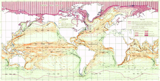
The Major Surface Current

Knowledge of surface ocean currents is essential in reducing costs of shipping, since they reduce fuel costs. In the sail-ship era knowledge was even more essential. A good example of this is the Agulhas current, which long prevented Portuguese sailors from reaching India. Even today, the round-the-world sailing competitors employ surface currents to their benefit.
The major surface currents in the world’s oceans are caused by prevailing winds. The currents may be cold, as in the instance of the West Wind Drift, or warm, as the Gulf Stream. Currents circulate in paths called gyres, moving in a clockwise direction in the northern hemisphere and a counterclockwise direction in the southern hemisphere.

Surface ocean currents are generally wind driven and develop their typical clockwise spirals in the northern hemisphere and counter-clockwise rotation in the southern hemisphere because of the imposed wind stresses. In wind driven currents, the Ekman spiral effect results in the currents flowing at an angle to the driving winds. The areas of surface ocean currents move somewhat with the seasons; this is most notable in equatorial currents.

Saturday, May 2, 2009

Ocean Shore and Tidal Pool

Tide pools with sea stars, sea anemone and sea sponges in Santa Cruz. Marine life is plentiful along shores and in tidal pools, where the sun penetrates to the floor and the fluctuating tide continually circulates resources. This beach is along the shore of the Pacific Ocean, at the Point of Arches in the Olympic National Park in the state of Washington.

Tide pools are rocky pools by oceans that are filled with seawater. Tide pools are habitats of uniquely adaptable animals that have engaged the special attention of naturalists and marine biologists, as well as philosophical essayists: John Steinbeck wrote in The Log from the Sea of Cortez, "It is advisable to look from the tide pool to the stars and then back to the tide pool again

Tide pool zones, from shallow to deep
Tide pools provide a home for hardy organisms. Inhabitants must be able to cope with a constantly changing environment — fluctuations in water temperature, salinity, and oxygen content. Huge waves, strong currents, exposure to midday sun and predators are only few hazards that tide pools animals should endure to survive.
Waves can dislodge mussels and draw them out to sea. Gulls pick up and drop sea urchins to break them open. Starfishs prey on mussels and are eaten by gulls themselves. Even large predators as black bears sometimes feast on tide pool creatures at low tide. Although tide pool organisms must struggle to avoid getting washed away into the ocean, drying up in the sun, or getting eaten, they depend on the tide pool's constant changes for food.

Tide pool flora
Sea anemone, Anthopleura elegantissima clone to reproduce. The process is called longitudinal fission. Few hours (or days) later after longitudinal fission has begun instead of one sea anemone there will be two. Sea anemones, Anthopleura sola are often seen to fight a war for territory. The white tentacles are fighting tentacles called acrorhagi. The acrorhagi contain stinging cells. The fighting sea anemones will continue to sting each other over and over again. After war ends one of them usually moves.

Tidal pool fauna

Low tide zone
This subregion is mostly submerged — it is only exposed at the point of low tide and for a longer period during extremely low tides. This area is teeming with life; the most notable difference of this subregion compared to the other three is that there is much more marine vegetation, especially seaweeds. There is also a great biodiversity. Organisms in this zone generally are not well adapted to periods of dryness and temperature extremes. Some of the organisms in the low tide zone area are abalone, anemones, brown seaweed, chitons, crabs, green algae, hydroids, isopods, limpets, mussels, nudibranchs, sculpin, sea cucumber, sea lettuce, sea palms, sea stars, sea urchins, shrimp, snails, sponges, surf grass, tube worms, and whelks.

Spray/splash zone
This zone gets spray during high tides and water during storms. At other times the rocks bake in the sun or are exposed to cold winds. Only few organisms can survive such harsh conditions. Lichens and barnacles live in this region. In this zone, different species of barnacle live in very tightly constrained locations, allowing the exact height of an assemblage above or below sea level to be precisely determined.
Since the intertidal zone periodically desiccates, barnacles are well adapted against water loss. Their calcite shells are impermeable, and they possess two plates which they can slide across their aperture when not feeding. These plates also protect against predation.

High and mid tide zone
The high tide zone is flooded for few hours every day during each high tide. The organisms there must survive wave action, currents, and exposure to the sun. The high tide zone is inhabited by sea anemones, starfishes, chitons, crabs, green algae, and mussels. Marine algae can provide shelter for such organisms as nudibranchs and hermit crabs. The same waves and currents that make the life in the high tide zone so difficult bring in food to the filter feeders and other tide pool animals.

Ocean floor

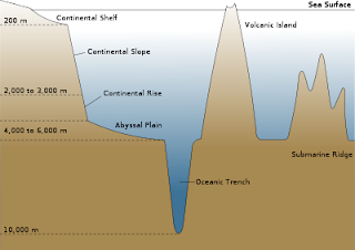
A variety of geographic and geologic features make up the ocean floor provinces, or regions. Shallow basins occur near the continental shelf and transition into the continental slope and continental rise. Deep marine trenches, such as the Mariana Trench in the Pacific Ocean, are usually found in volcanically active regions.

The Pacific Ocean has many seamounts, such as volcanoes and flat-topped guyots. In other places, the ocean floor forms a flat, abyssal plain. The abyssal plain covers more than 30 percent of Earth’s surface.


Diagrammatic cross-section of an ocean basin, showing the various geographic features. Note significant vertical exaggeration.
Abyssal plains are flat or very gently sloping areas of the deep ocean basin floor. They are among the Earth's flattest and smoothest regions and the least explored. Abyssal plains cover approximately 40% of the ocean floor and reach depths between 2,200 and 5,500 m (7,200 and 18,000 ft). They generally lie between the foot of a continental rise and a mid-oceanic ridge.

The abyssal plain is formed when the lower crust (sima), is melted and pushed up by the up-welling mantle, reaches the surface at mid-ocean ridges and forms new oceanic crust. This new oceanic crust is mostly basalt and has a rugged topography. The roughness of this topography is a function of the rate at which the mid-ocean ridge is spreading (the spreading rate). Magnitudes of spreading rates vary quite significantly, and are generally broken down into 3 rates (fast, medium and slow). Typical values for fast-spreading ridges are >100 mm/yr, whilst medium-spreading rates are ~60 mm/yr, and slow-spreading ridges are typically <20 mm/yr. Studies have shown that the slower the spreading rate, the rougher the new oceanic crust will be, and vice versa. It is thought this is due to faulting at the mid-ocean ridge when the new oceanic crust was formed. This oceanic crust eventually becomes overlain with sediments, producing the flat appearance.

Map of the Ocean Floors

This map highlights the topography of the seabed under the earth’s oceans. Ocean depth varies amid the basins, plains, trenches, mountains, ridges, and volcanoes that line the ocean floors. With its variety of geological features, the seabed resembles the continental landscape.

Formation of an Oceanic Ridge


An oceanic ridge develops on the ocean floor where the boundaries of tectonic plates meet. Molten rock is forced up at these boundaries and pushes the oceanic crust up and outward, creating the ridge.

Antarctic Gyre (Current Wheel)

All of the oceans are linked by a clockwise flow around the South Pole. This flow is called the Antarctic gyre, or the current wheel. The clockwise flow around the South Pole results from the way currents of the Atlantic, Pacific, and Indian Oceans circulate counterclockwise.


Flotaing Island of Plastic Near the
North Pacific Subtropical Gyre.